To be listed on the haciendadelalamo TODAY MAP please call +34 968 018 268.
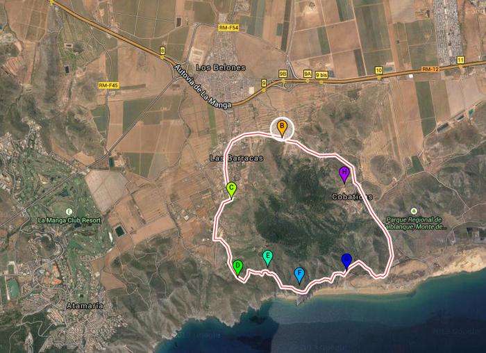
8-kilometre geological walk around Cabezo de la Fuente in Calblanque regional park
A circular geological route in the Cartagena countryside
Sendero Circular Cabezo de la Fuente:
Length: 8 km
Difficulty: medium
Start point: Las Cobaticas information centre
The Calblanque regional park (Parque Regional de Calblanque, Monte de las Cenizas y Peña del Águila) in the municipality of Cartagena is an extensive natural park, with a wide range of environmental conditions and natural features, as well as long, wide beaches and plenty of native flora and fauna. But it is also a site of great geological interest and this 8-km route through the park, which begins and ends at the information centre of Las Cobaticas, is described as being of medium difficulty and includes the following points of geological interest:
1. The La Jordana phyllite quarry: this old quarry was mined for red-violet phyllites known locally as “láguena” or “launa”, which was used to provide waterproof roofing on traditional houses.
2. The spring at Fuente Grande: this mountain spring is the result of the contact between permeable and impermeable materials which causes water to accumulate. It emerges at a height of 100 metres above sea level with a flow rate of 0.5 litres per second.
3. The Mirador del Cabezo de La Fuente: from here the view includes the 336-metre-high mountain of Cabezo de la Fuente, the upper part of which is formed by dolostones and cream-coloured sedentary limestone which rests on violet-coloured quartz phyllite. Below lie older metamorphic rocks.
4. The Galería de Búsqueda: this is an old mine shaft which was dug in search of minerals on account of the iron oxide on the surface. This usually indicates the presence of silver-rich galena, and 50 metres from the shaft is a gallery next to some marble rocks where lead and silver were also prospected for.
5. A collection of fallen rocks: on the lower slopes it is possible to see large dolostones which have fallen relatively recently due to the erosive process which has also resulted in the sharp peak of the Cabezo de la Fuente. Before reaching Playa Parreño the path runs through these rocks, the surface of which is coated in calcium carbonate.
6. Glacis of Playa Parreño: looking towards Playa Parreño it is possible to see material which has been eroded from the slopes of the mountain forming a gradual slope down towards the sea. This formation is known as a glacis, and it is possible to see how rainwater flowing towards the sea has formed channels in the glacis.
7. Folds of Las Cobaticas: On returning to the information centre walkers can observe isoclinal folds in the rocks which were produced at the time when the mountains were formed by the compressive forces of tectonic plate movements.
The following safety advice is offered:
Remain on the indicated path and follow the markers
Wear strong shoes, and suitable clothing as well as suncream, hat and sunglasses
Avoid strong sun, wind or rain
Advise a family member or friend of your intentions and carry a mobile phone
Carry water and a snack, but take all rubbish home
Respect the park and its flora and fauna
Click for start point, Visitor Centre of Los Cobaticas, Cartagena
The natural park of Calblanque is in the east of the municipality of Cartagena. Click Cartagena for more information about Cartagena, its history, restaurants and all the different places to visit and things to do within the municipality.
This park also lies within the area broadly classified as the Mar Menor. Click Mar Menor to go to the dedicated Mar Menor section which gathers together places to visit, restaurants, things to do, what’s on and local news,
Click for map, Cabezo de la Fuente


